UNIST site map
- Admissions
-
Academics
- Colleges and Schools
-
Academic Affairs
- Academic Calendar
- Academic Curriculum
- Requirements for Graduation
- Browse Open Courses
- Undergraduate Administration
-
Graduate Academic Affairs
- Tuition Fee Payment
- Academic Leave of Absence/ Academic Return
- Voluntary Withdrawal/ Expulsion
- Change of Major
- Change of Degree Program/ Dropping of Degree Program
- Class Period/ Attendance Period/ Academic Year・Semester
- Course Registration
- Course Drop
- Attendance/ Grade/ Exam
- Credit Transfer/ Credit Carryover
- Academic Forms
- Education Support
-
Research/Industry
- Research Aims
- Research Findings
- Researcher Search
-
Research Organizations
- UNIST Multi-Interdisciplinary Institute
- IBS Research Groups
-
UNIST Labs
- Department of Mechanical Engineering
- School of Energy and Chemical Engineering
- Department of Civil
- Department of Materials Science and Engineering
- Department of Nuclear Engineering
- Department of Industrial Engineering
- Department of Design
- Department of Biomedical Engineering
- Department of Biological Sciences
- Department of Electrical Engineering
- Department of Computer Science and Engineering
- Department of Mathematical Sciences
- Department of Chemistry
- Department of Physics
- School of Business Administration
- Graduate School of Carbon Neutrality
- Graduate School of Artificial Intelligence
- Research Support
- University-Industry Relations
- Campus Life
- News Center
- About UNIST
-
etc
- UNIST Bulletin
- Work-Life Balance Support System
- UNIST Gender Equality Plan
- Faculty Invitation for Tenure Track
- Faculty Invitation for Non-Tenure Track
- Board Meeting Minutes
- University Council Meeting Minutes
- Administrative Service Charter
- Privacy Policy
- Copyright Policy
- Rejection of Unauthorized Email Collection
- Information Disclosure
SEARCH


Connection Points of Knowledge, Everything About UNIST
Try searching.
Recommended search terms


STUDENT


- portal
- U Academics Innovation Center
- Leadership Center
- Dormitory
- Academic Information Center
- International Students Support
- Browse Open Courses
- Course Registration
- Graduation Requirements for Graduation
- Academic Leave of Absence/ Academic Return
- Military Service
- Certificate Issuance
- Academic Calendar
- Scholarships
- Campus Map
- Campus Life Guidebook
- Health Care Center
- Human Rights Center
- portal
- Job Opening
- Announcement for Bid
- UNIST AI Services
- UNIST Daycare Center
- Sports Center
- UI Downloads
- Announcement
- Recruitment of Professors (Non-tenure)
- Faculty Invitation for Tenure Track
- UNIST Academic Information Center
- Office of Research Facilities and Training
- Office of Research Affairs
- Rule Management System
- Academic Calendar
![]()
![]()
This is a collection of menus necessary for UNIST students .
students
- portal
- U Academics Innovation Center
- Leadership Center
- Dormitory
- Academic Information Center
- International Students Support
- Browse Open Courses
- Course Registration
- Graduation Requirements for Graduation
- Academic Leave of Absence/ Academic Return
- Military Service
- Certificate Issuance
- Academic Calendar
- Scholarships
- Campus Map
- Campus Life Guidebook
- Health Care Center
- Human Rights Center
![]()
![]()
This is a collection of menus necessary for prospective UNIST Students .
prospective Students
![]()
![]()
This is a collection of menus necessary for UNIST Faculty & Staff .
Faculty & Staff
- portal
- Job Opening
- Announcement for Bid
- UNIST AI Services
- UNIST Daycare Center
- Sports Center
- UI Downloads
- Announcement
- Recruitment of Professors (Non-tenure)
- Faculty Invitation for Tenure Track
- UNIST Academic Information Center
- Office of Research Facilities and Training
- Office of Research Affairs
- Rule Management System
- Academic Calendar


NEWS CENTER
Discover not only Research Findings and event news, but also the diverse facets of UNIST presented by reporters and writers.
News Center

UNIST News
총 944건의 게시물이 있습니다.
There are a total of 944 posts.
-
Research
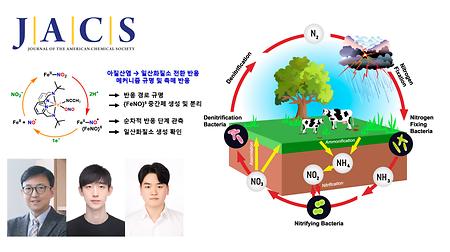
Breakthrough Observation of Transient Intermediate in Nitrite-to-Nitric Oxide ConversionThe findings were published in the Journal of the American Chemical Society (JACS) on March 20, 2026.Abstract The reduction of nitrite (NO2–) to nitric oxide (NO) is a fundamental transformation within both the global nitrogen cycle and enzymatic signaling pathways. Although extensively investigated, the elusive {FeNO}6 intermediate implicated in the 2H+/1e– reduction pathway has rarely been observed or isolated due to the inherent instability. Here, we present a comprehensive mechanistic investigation of nitrite reduction by a mononuclear iron(II)-nitrite complex, [FeII(TBDAP)(NO2)(CH3CN)]+ (1) (TBDAP = N,N′-di-tert-butyl-2,11-diaza[3.3](2,6)-pyridinophane). Treatment of 1 with 2.5 equiv of triflic acid (HOTf) affords the {FeNO}6 (2) intermediate, which was characterized using a combination of various physicochemical techniques and DFT calculations. Isotopic labeling using Na15NO2 confirmed the formation of 2 via heterolytic N–O bond cleavage. Kinetic studies revealed a HOTf-independent rate constant and a markedly negative value of activation entropy for the formation of 2, suggesting that the rate-determining step involves an associative reaction between Fe(II) and NO+. Electrochemical analysis showed a reversible redox couple for 2, and subsequent one-electron reduction by ferrocene released NO. The generation of NO was confirmed through trapping experiments using [Co(TPP)], resulting in the formation of [Co(TPP)(NO)]. The experimental findings establish {FeNO}6 as an isolable and reactive intermediate, offering new insight into the mechanistic landscape of nitrite reduction. Researchers from UNIST and Jeonbuk National University have, for the first time, captured and analyzed a short-lived iron (Fe)-based intermediate involved in converting nitrite (NO2–) to nitric oxide (NO)—a key process in the nitrogen cycle and biological signaling. This discovery, made at ultra-low temperatures, provides new insights into how vital molecules are produced in nature and in biological systems. Using a specialized Fe(ll)-nitrite complex and reaction conditions at -40°C, Professor Jaeheung Cho from the Department of Chemistry at UNIST, in collaboration with Professor Kyung-Bin Cho at Jeonbuk National University isolated the elusive {FeNO}⁶ intermediate, a critical step preceding NO release. Spectroscopic and computational analyses confirmed that this species forms after NO2– accepts a proton and undergoes bond cleavage, with the nitrogen-oxygen ion binding to Fe. Further electron transfer then liberates NO. The study also revealed that the reaction pathway varies depending on whether proton and electron transfers occur sequentially or simultaneously, providing nuanced insight into reaction mechanisms. Professor Cho remarked, “This is the first direct observation of the intermediate in NO2– reduction to NO. Understanding this step could inform targeted therapies for vascular diseases and inspire the design of new catalysts with improved efficiency.” According to the research team, this discovery advances fundamental knowledge of nitrogen cycle chemistry and biological NO production, with potential applications in medicine and sustainable catalysis. By elucidating the reaction pathway, the research opens avenues for developing innovative treatments and catalytic systems. These findings were published in the Journal of the American Chemical Society (JACS) on March 20, 2026. The study has been supported by the Ministry of Science and ICT (MSIT), the National Research Foundation of Korea (NRF), and the Ministry of Health and Welfare (MOHW). Journal Reference Seungwon Sun, Youngjin Jeon, Youngseob Lee, et al., “Unveiling an {FeNO}6 Intermediate: A Sequential Mechanistic Investigation of Nitrite Reduction in a Mononuclear Iron(II) Complex,” JACS, (2026).- 2026-04-16
- JooHyeon Heo
- 204
-
Research
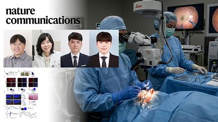
Targeted Nanoparticles Eliminate Aging Retinal Cells to Reverse Vision DeclineThe findings of this research were published in Nature Communications on March 18, 2026.Abstract Sensitive cells contribute to degenerative processes in multiple tissues, including the retina. In the retinal pigment epithelium (RPE), their accumulation is closely associated with retinal aging and disease progression. Eliminating senescent RPE cells has shown therapeutic potential, but conventional senolytics often lack the specificity required to spare non-senescent cells, raising safety concerns. To overcome this, we performed integrated transcriptomic analyzes of male mouse-derived RPE cells under natural aging and chemically induced senescence conditions. These analyzes identified Bst2 as a membrane-localized marker selectively upregulated in senescent RPE cells, with minimal expression in young controls. Based on this discovery, we developed a modular, antibody-pluggable drug delivery platform–BZ-PON–comprising mesoporous silica nanoparticles functionalized with a recombinant Fc-binding domain and conjugated with anti-Bst2 antibodies. This nanocarrier selectively accumulates in Bst2-expressing senescent RPE cells, enabling targeted drug delivery and sparing healthy retinal cells. In vivo administration of ABT-263-loaded BZ-PON in aged and senescence-induced retinal degeneration models resulted in the selective ablation of senescent cells, restoration of RPE function, and improved visual outcomes. Together, our study integrates senescence-specific marker discovery with precision nanomedicine, establishing a versatile platform for targeted senotherapy. These findings offer a promising therapeutic approach for retinal aging disorders, such as age-related macular degeneration. A collaborative team of researchers from UNIST and Konkuk University College of Medicine has introduced an innovative nanotechnology platform that precisely targets and removes aging retinal cells, leading to partial restoration of vision in mouse models. This advancement opens new possibilities for treating age-related macular degeneration (AMD), a leading cause of blindness worldwide. As the global population ages, the incidence of AMD continues to rise, damaging the central retina and impairing vision. Current treatments primarily address symptoms but do not fundamentally halt disease progression. The new platform specifically eliminates senescent retinal pigment epithelium (RPE) cells—cells that, when aged, secrete harmful substances that exacerbate retinal degeneration. Led by Professor Ja-Hyoung Ryu from the Department of Chemistry at UNIST and Professor Hyewon Chung from the Department of Ophthalmology at Konkuk University College of Medicine, the research team developed mesoporous silica nanoparticles functionalized with antibodies targeting Bst2, a protein uniquely overexpressed on the surface of senescent RPE cells. These nanoparticles deliver a potent senolytic drug, ABT-263, directly into the aged cells. Once inside, they release the drug, inducing cell death while sparing healthy tissue. The design also ensures safety: even if nanoparticles bind to normal cells, they remain inactive unless exposed to the high-glutathione environment characteristic of senescent cells. In vivo experiments demonstrated that intravitreal injection of these drug-loaded nanoparticles selectively removed senescent cells without harming healthy tissue, resulting in significant improvements in retinal electrical responses and partial recovery of visual function in mice. Professor Chung emphasized, “Our targeted approach addresses the disease at its root, moving beyond symptom management. This could revolutionize treatment for dry AMD and other age-related degenerative conditions.” Professor Ryu added, "By identifying a novel marker and engineering targeted nanocarriers, we have paved the way for highly specific therapies that can be adopted to other age-related diseases by simply changing the targeting antibody." The findings of this research were published in Nature Communications on March 18, 2026. This study has been supported by the Ministry of Science and ICT (MSIT), the National Research Foundation of Korea (NRF), and the Korean ARPA-H Project through the Korea Health Industry Development Institute (KHIDI), funded by the Ministry of Health and Welfare (MOHW). Journal Reference Jun Yong Oh, Jae-Byoung Chae, Hyo Kyung Lee, et al., “Bst2-targeted senotherapy restores visual function by eliminating senescent retinal cells,” Nat. Commun., (2026).- 2026-04-15
- JooHyeon Heo
- 179
-
Research
Turning Solar Panel Waste into Hydrogen and High-Value SilicaThe research was published in the online version of Joule on March 27 and highlighted in its Future Energy section.
Summary Although Earth's abundant silicon (Si) is thermodynamically reactive with water to produce hydrogen (H2) and silicon oxide (SiO2, silica), the Si-water reaction is kinetically self-limited by the silica passivation layer that spontaneously forms on Si surfaces. If this limitation of the Si-water reaction can be overcome, hydrogen (H2) can be directly produced from water. Here, we demonstrate that “dynamic” mechanochemistry can overcome the self-limitation of the Si-water reaction, without using corrosive additives, to reach the theoretical limit. As one real-world application, upcycling end-of-life silicon solar panels was performed, with techno-economic analysis suggesting the strong competitiveness of the proposed method for the Si-water reaction. High-purity hydrogen (∼100%) gas and solid silica as a value-added product were produced under a separation-free process. In response to the growing accumulation of end-of-life solar panels, researchers at UNIST have unveiled an innovative, environmentally friendly method to convert photovoltaic silicon into high-purity hydrogen and valuable silica. Led by Professor Jong-Beom Baek from the School of Energy and Chemical Engineering at UNIST, this breakthrough promises to revolutionize solar panel recycling and sustainable hydrogen production. The team led by Professor Jong-Beom Baek developed a mechanochemical process that overcomes the self-limiting silica passivation layer on silicon surfaces. By placing silicon and water with small abrasive beads into a rotating vessel, repeated mechanical collisions strip the silica layer, enabling the reaction to proceed to nearly its theoretical maximum. Experimental results show approximately 1,706 mL of hydrogen per gram of silicon—achieving 99.6% of the maximum yield, significantly surpassing conventional thermochemical methods. Moreover, the silica byproduct serves as an effective catalyst support. When used with nickel catalysts, it enhances carbon dioxide conversion and methane selectivity, thanks to its high surface hydroxyl density that improves catalyst dispersion. “By leveraging waste silicon from decommissioned solar panels, our process produces high-purity hydrogen efficiently while also recovering valuable silica for industrial applications,” says Professor Jong-Beom Baek. “This approach not only advances sustainable energy but also contributes to resource circularity and environmental protection.” This technology offers a cost-effective, scalable, and environmentally benign alternative to traditional photovoltaic waste management. Operating continuously, the process boasts higher productivity and energy efficiency, making it suitable for industrial deployment. It paves the way for a circular economy in solar energy, transforming waste into valuable resources and supporting the global shift toward clean hydrogen. The findings of this research were published in the online version of Joule on March 27 and were highlighted in the journal's Future Energy section. The study has been supported by the Ministry of Science and ICT (MSIT) and the National Research Foundation of Korea (NRF). Journal Reference Yanhua Shao, Runnan Guan, Jiwon Gu, et al ., “Reaching the theoretical limit of H2 production from the self-limiting silicon-water reaction via dynamic mechanochemistry,” Joule , (2026).- 2026-04-14
- JooHyeon Heo
- 337
-
Research
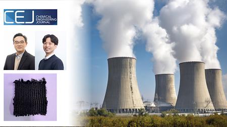
New Study Unveils High-Performance Porous Carbon Fiber for Rapid Removal of Radioactive IodineThe findings of this research have been published in Chemical Engineering Journal on April 1, 2026.Abstract The effective removal of nuclear waste from fission has attracted significant attention, with numerous porous sorbents reported in recent decades. The practical application of current sorbents is often hindered by limited removal efficiency and low production scalability. Here, we developed activated carbon fibers (ACFs) as an ultrafast and effective iodine capture material using a scalable method. The engineered ACFs possess and extraordinary micro/mesoporous structure with a surface area exceeding 2900 m2 g−1 while maintaining mechanical and thermal stability. The resulting fibers demonstrate a superior iodine capture capacity of 3.10 g g−1 and a capture rate of 2.76 g g−1 h−1. To further augment these properties, a novel oxygen-doping strategy was implemented. This approach dramatically improves performance, achieving 51% higher capacity (4.68 g g−1) and 76% faster rate (4.86 g g−1 h−1). Notably, exfoliation reactions of iodine within carbon layers that induced structural changes were discovered. Our work underlines the promise of ACFs for nuclear waste management. A joint research team, led by Professors Han Gi Chae and Seung Geol Lee from the Department of Materials Science and Engineering at UNIST has unveiled a novel, ultra-porous carbon fiber capable of quickly capturing radioactive iodine gases—a critical challenge in nuclear waste treatment and environmental safety. This scalable material demonstrates exceptional adsorption capacity and speed, with potential applications in nuclear facilities and emergency response. The engineered carbon fibers feature an extraordinary surface area exceeding 2,980 m² per gram, thanks to a manufacturing process that creates diverse pore sizes and incorporates oxygen doping. This structure enables the fibers to adsorb up to 4.68 grams of iodine per gram—over 1.5 times higher than conventional materials—and reach saturation within approximately 100 minutes. The oxygen doping enhances the chemical interaction with iodine, further boosting performance by 51% in capacity and 76% in adsorption rate. Additionally, the fibers maintain over 90% of their initial capacity after multiple reuse cycles, supporting cost-effective, large-scale deployment. The fabrication process is straightforward and cost-efficient, avoiding complex shaping steps typical of other materials like metal-organic frameworks (MOFs), making mass production feasible. Professor Han Gi Chae explains, “Our findings reveal the dynamic structural changes during iodine adsorption, providing new insights into how porous carbon materials interact with hazardous gases. This advancement could revolutionize safety measures in nuclear waste management and environmental remediation.” This innovative material offers a practical, scalable solution for rapid iodine removal, essential for nuclear safety and environmental protection. Its ease of production and reusability pave the way for widespread application in nuclear facilities, accident response systems, and pollutant treatment. The findings of this research have been published in Chemical Engineering Journal on April 1, 2026. The study has been supported by the Ministry of Trade, Industry and Energy (MOTIE), the Korea Planning & Evaluation Institute of Industrial Technology (KEIT), and the Ministry of Science and ICT (MSIT). Journal Reference Changbeom Jeon, Hyejin Lee, Ga-Hyeun Lee, et al., "Simple oxygen doping strategy for highly porous carbon fibers enabling ultrafast and efficient iodine capture," Chem. Eng. J., (2026).- 2026-04-13
- JooHyeon Heo
- 217
-
Research
UNIST Unveils AI-Driven Framework for Real-Time Multi-Pollutant Air Quality MonitoringThe findings of this research have been published in Environmental Science & Technology on March 20, 2026.Abstract Simultaneous prediction of multiple air pollutants is essential for quantifying human co-exposure and evaluating the health impacts of pollutant mixtures. However, spatial and temporal gaps in geostationary satellite observations, chemical transport models, and ground-based monitoring networks hinder accurate hourly assessments of multi-pollutant dynamics. Here, we present Deep Learning for Multiple Air Pollutant analysis (DeepMAP), a deep learning framework that simultaneously predicts six major air pollutants─PM10, PM2.5, O3, NO2, CO, and SO2─at hourly resolution. DeepMAP demonstrated robust performance across multiple pollutants and generalized well to unseen regions. The framework accurately captured dynamic high-concentration co-pollution episodes during March 2021, with normalized RMSE values below 0.36 for all pollutants. DeepMAP revealed that PM10-PM2.5 co-exceedance was the most frequent across East Asia (91 days/year), followed by PM10-PM2.5-NO2 (42), PM2.5-O3 (18), and PM10-PM2.5-O3 (12). Hotspots for PM10-PM2.5-NO2–O3 co-exceedance were identified over the North China Plain, East China, and South Korea, where the regional annual totals reached 24, 19, and 15 days, respectively. A novel co-exposure index further identified three distinct hotspot regions where the contribution of NO2 was approximately twice that observed elsewhere. Our findings provide a high-resolution, data-driven framework for characterizing multi-pollutant co-exposure and identifying regional priorities for air quality management and public health protection. A research team, led by Professor Jungho Im from the Department of Civil, Urban, Earth, and Environmental Engineering at UNIST, has introduced DeepMAP, a cutting-edge artificial intelligence model that accurately estimates hourly levels of six key air pollutants across East Asia. The technology, developed from 2021 to 2023, provides new insights into the widespread and simultaneous exceedance of air quality standards, with significant implications for health policies and environmental management. DeepMAP integrates diverse data sources—including geostationary satellite imagery, atmospheric chemical transport models, meteorological data, and ground observations—to produce real-time, high-resolution maps of PM10, PM2.5, O₃, NO₂, SO₂, and CO. Operating at a 10 km spatial resolution and providing hourly predictions, the model captures dynamic pollution patterns and hotspots, revealing that Korea experiences about 15 days per year with four pollutants exceeding WHO safety thresholds simultaneously. Unlike traditional methods that estimate pollutants individually, DeepMAP’s multi-task learning approach models interactions among pollutants, significantly enhancing estimation accuracy. “By accurately capturing the complex interplay of multiple pollutants in real time, our model offers a powerful tool for assessing exposure risks and guiding effective policy decisions,” said Professor Jungho Im, lead researcher. “This represents a major step toward more realistic and comprehensive air quality management.” The study underscores the health risks posed by combined pollutant exposure, which can worsen respiratory and cardiovascular diseases. Traditional monitoring methods often fall short in providing detailed, regional, and real-time data. DeepMAP’s capabilities open new avenues for environmental monitoring, public health research, and proactive policymaking, especially during pollution episodes driven by seasonal phenomena like dust storms and high-pressure systems. The findings of this research have been published in Environmental Science & Technology on March 20, 2026. The study has been supported by the National Institute of Environmental Research (NIER) under the Ministry of Environment (ME), and by the National Research Foundation of Korea (NRF), funded by the Ministry of Science and ICT (MSIT). Journal Reference Eunjin Kang, Sihun Jung, Jungho Im, et al., "Quantifying Multi-pollutant Co-exposure via Deep Learning-Based Simultaneous Prediction Using Geostationary Satellite Data," Environ. Sci. Technol., (2026).- 2026-04-10
- JooHyeon Heo
- 398
-
Research
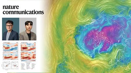
Sea Surface Temperature Shifts in the Pacific Improve Year-Ahead Winter Climate PredictionsThe findings of this research have been published in Nature Communications on March 25, 2026.Abstract The winter North Atlantic Oscillation (NAO) is a dominant mode of climate variability affecting temperature and precipitation across the Northern Hemisphere, yet its prediction at seasonal-to-decadal (S2D) lead times remains challenging. Here, using multi-year hindcasts from a multi-model ensemble initialized on 1 November for 1962–2019, we show that NAO skill one year ahead improves significantly when the El Niño–Southern Oscillation (ENSO) undergoes a phase transition next year. This improvement is linked to the northward propagation of anomalous atmospheric angular momentum, which dynamically organizes the NAO and is captured in reanalysis and models. During ENSO transition years, prediction skill increases with ensemble size, and when more than 10 members are used, the forecasts display the signal-to-noise paradox. These findings highlight the potential for enhanced one-year NAO predictability when ENSO transitions are present and large ensemble sizes are used in S2D prediction systems, given the skillful prediction of ENSO phase transitions at one-year lead times by multi-model ensembles. A research team, affiliated with UNIST, in collaboration with the UK Met Office Hadley Centre, has identified that major changes in the equatorial Pacific’s sea surface temperatures—such as transitions between El Niño and La Niña—significantly boost the accuracy of winter weather forecasts in the Northern Hemisphere. Led by Professor Myong-In Lee in the Department of Civil, Urban, Earth, and Environmental Engineering, their findings mark a breakthrough in understanding how tropical Pacific variability influences mid-latitude climate prediction. The study reveals that during ENSO transition years, the correlation coefficient for NAO prediction improves markedly—up to 0.60—compared to near-zero correlations in stable ENSO years. This phenomenon occurs because the oceanic temperature changes trigger atmospheric angular momentum shifts that gradually propagate northward, affecting the NAO pattern approximately one year later. The process involves the interaction of delayed effects—initiated by sea surface temperature anomalies—and the rapid transfer of atmospheric signals via Rossby waves, large-scale planetary waves influenced by Earth's rotation. “During ENSO transition years, the tropical ocean changes significantly influence the atmospheric circulation, strengthening the signals used for long-term forecasting,” explained Professor Myong-In Lee. “This understanding can help improve climate prediction models and support strategic planning in sectors like agriculture and energy.” These insights provide a crucial step toward enhancing Korea’s climate prediction capabilities and developing more accurate regional models. By understanding the dynamical mechanisms linking tropical Pacific variability to Northern Hemisphere winter patterns, researchers can improve forecasts for long-term climate variability, aiding disaster preparedness and resource management. This research was supported by the Korea Meteorological Administration and the National Institute of Meteorological Sciences, through projects focused on operational climate prediction systems and climate crisis response strategies. The findings of this research have been published in Nature Communications on March 25, 2026. The study has been supported by the Korea Meteorological Administration (KMA) and the National Institute of Meteorological Sciences (NIMS), through projects focused on operational climate prediction systems and climate crisis response strategies. Journal Reference Satyabrat Behera, Jong Sung Moon, Kirlie Iulius Figuera Michal, et al., "Electrical Control of Single Photon Emitters in WSe2 on a Si Nanopyramid Array with a Negligible Stark Effect," Nano Lett., (2026).- 2026-04-10
- JooHyeon Heo
- 337
-
Research
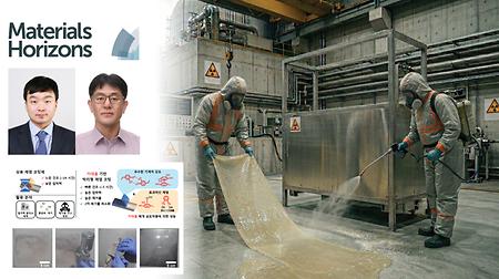
New Study Unveils Mussel-Inspired Coating for Rapid Radioactive Surface DecontaminationThe findings of this research have been published online in the March 2026 issue of Materials Horizons.Abstract Efficient and rapid decontamination of radioactive elements is important to prevent radioactive exposure. Herein, we develop a strippable catechol-terminated polyurethane (CPU) coating for effective surface decontamination. Our polyurethane coating can be directly applied to contaminated surfaces via simple spraying or solution casting, followed by rapid drying at room temperature. The resulting coating is easily stripped off with sufficient toughness and adhesion strength, showing superior 137Cs removal efficiency on stainless steel (∼94.9%) and rough cement (∼59.1%), in a much shorter time (<3 h) compared to commercial decontamination coatings (∼93.8% on stainless steel and ∼8.4% on cement after 24 h). This performance can be attributed to the strong adhesion and cohesion mediated by catechol moieties. Furthermore, after use, the coating waste is readily dissolvable in acetone, suggesting potential for reducing radioactive waste with the aid of an appropriate separation process, thereby preventing secondary contamination. These results establish CPU as a promising radioactive decontamination strategy. Professor Dong Woog Lee from the School of Energy and Chemical Engineering at UNIST, in collaboration with the Korea Atomic Energy Research Institute (KAERI) have unveiled a novel, mussel-inspired polyurethane coating capable of removing over 95% of radioactive cesium from surfaces in just three hours—far faster than existing methods. This breakthrough promises to enhance safety and efficiency in nuclear decontamination efforts. The innovative coating utilizes catechol groups—derived from mussel adhesion proteins—attached to polyurethane polymer chains, creating a highly adhesive surface. Applied onto contaminated surfaces, the coating dries within hours and can be peeled off like tape, effectively removing radioactive particles. Laboratory tests demonstrated a cesium removal efficiency of 94.9% on stainless steel and 13.1% on porous cement surfaces after two applications, outperforming commercial products that typically require 24 hours. Additionally, the coating can be dissolved in acetone post-use, enabling waste separation and reducing secondary contamination. Dr. Heeman Yang, lead researcher from KAERI, stated, “This technology offers a faster, more effective, and environmentally conscious approach to decontamination. Its ability to rapidly remove radioactive materials while facilitating waste management marks a significant advancement in nuclear safety.” This development addresses critical needs in nuclear facility decontamination, emergency response, and waste reduction. By combining speed, efficiency, and eco-friendliness, the coating holds promise for broad application in nuclear safety and environmental management, contributing to safer decommissioning and accident mitigation in the future. The findings of this research have been published online in the March 2026 issue of Materials Horizons. The study has been supported by the Institute of Civil Military Technology cooperation, funded by the Defense Acquisition Program Administration and the Ministry of Trade, Industry and Energy (MOTIE). Journal Reference Jae Seung Lee, Ye-won Jeong, Donghyun Kim, et al., "A strippable catechol-terminated polyurethane coating for large-area radioactive cesium decontamination," Mater. Horiz., (2026).- 2026-04-09
- JooHyeon Heo
- 398
-
Research
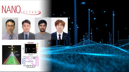
New Study Unveils High-Purity, Electrically Controlled Single-Photon Source for Quantum TechnologiesThe findings of this study have been published in the online version of Nano Letters on March 11, 2026.Abstract Single-photon emitters (SPEs) based on two-dimensional (2D) materials have attracted a lot of attention due to their unique benefits such as mechanical flexibility, high quantum yield, and easy integration on a chip. However, the electrical modulation of such emitters at a single-photon level still remains a challenge. Herein, we provide a new route to engineer electrically controllable purified SPEs in a monolayer (1L) WSe2 using a Si nanopyramid structure. The Si nanopyramid structures allow not only the generation of high strain to localize the SPEs but also the application of voltage for electrical modulation. Of particular interest, while our structure modulates the single-photon emission with an applied gate voltage, it does not exhibit unwanted spectral shift for the applied voltage, i.e., a negligible Stark effect, due to the existence of an air gap between the 1L-WSe2 and the nanopyramid. The single photon purity is improved by electrical modulation down to g(2)(0) = 0.06 ± 0.03. Researchers at UNIST have developed a novel single-photon emitter (SPE) that can be electrically switched on and off with high purity and stability. This breakthrough addresses key challenges in quantum device engineering, paving the way for scalable quantum computing and secure quantum communication. Based on a 2D semiconductor integrated with a silicon nanopyramid structure, the device generates single photons with minimal spectral shift during electrical modulation. By engineering a nanoscale air gap, the team effectively suppresses the Stark effect—preventing energy shifts in emitted photons—while maintaining a high level of single-photon purity (g(2)(0) ≈ 0.06). This design also reduces background emissions from defects, enhancing overall performance. “This work represents a significant step toward integrated quantum photonics,” said the research team. “Controlling single photons electrically without spectral degradation opens new possibilities for scalable quantum devices.” This study has been participated by Satyabrat Behera and Jong Sung Moon, as first authors of the study. Published in the March 2026 issue of Nano Letters, the research was supported by the IITP (Institute of Information & Communications Technology Planning & Evaluation)-ITRC (Information Technology Research Center) program by the Ministry of Science and ICT (MSIT), the National Research Foundation of Korea (NRF), and UNIST. Journal Reference Satyabrat Behera, Jong Sung Moon, Kirlie Iulius Figuera Michal, et al., "Electrical Control of Single Photon Emitters in WSe2 on a Si Nanopyramid Array with a Negligible Stark Effect," Nano Lett., (2026).- 2026-04-08
- JooHyeon Heo
- 427
-
Research
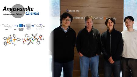
When Chemical Intuition Meets Neural Networks: Hybrid AI Algorithm Predicts Metal–Ligand Coordination StructuresTheir findings have been published in Angew. Chem. Int. Ed. on February 21, 2026.Hemoglobin, which gives blood its red color, the light-emitting materials in smartphone OLED displays, and catalysts used in manufacturing plastics and pharmaceuticals—all share a common feature that is they all involve metal–ligand coordination complexes. In these structures, a central metal ion is surrounded by organic molecules, known as ligands. Now, a novel artificial intelligence (AI) algorithm offers the promise of designing these complex materials more swiftly and accurately, significantly reducing trial-and-error efforts. Predicting how a metal ion will 'shake hands' with an organic molecule is an inherently complex task, often challenging even for seasoned scientists. This difficulty arises because organic ligands contain multiple potential binding sites, and the number and mode of coordination can vary widely depending on the specific metal and its oxidation state. As a result, dozens or even hundreds of potential structural configurations can exist. Led by Distinguished Professor Bartosz A. Grzybowski of the Department of Chemistry and Director of the Center for Algorithmic and Robotized Synthesis (CARS) within the Institute for Basic Science (IBS) at UNIST, the research team has addressed this challenge not through increased computational power, but by integrating 'chemical intuition' directly into AI. Published in Angewandte Chemie, their hybrid AI approach moves beyond simple pattern recognition by encoding fundamental chemical principles into neural networks. Figure 1. An AI-powered hybrid model predicts metal–ligand coordination modes by integrating chemical rules from crystal structures with machine learning, enabling accurate design of complex organometallic structures. "We have developed a 'hybrid' strategy that combines classical chemical knowledge with machine learning to accurately predict how metals and organic ligands bind," explains Professor Grzybowski. "By analyzing over 100,000 crystal structures from the Cambridge Structural Database, we trained a model that 'understands' the specific behavior of different metals and their oxidation states—something previous models could not achieve." This innovative technology is poised to become a key component in large-scale computational pipelines. Professor Grzybowski notes, “We expect it to be highly valuable in designing transition metal catalysts used across industries—from pharmaceuticals to advanced functional materials.” To make this cutting-edge tool accessible worldwide, the team has released RDMetallics, an open-source, Python-based software package, along with a dedicated web portal (coordinate.rdmetallics.net). Researchers anywhere in the world can now predict complex metal–ligand coordination modes directly through their web browsers—no coding skills or expensive hardware required. Supported by the Institute for Basic Science (IBS), this research was published online on Angewandte Chemie International Edition on February 21, 2026. Bartosz A. Grzybowski Distinguished Professor, Department of Chemistry, UNIST Director, IBS Center for Robotized and Algorithmic Synthesis (CARS) E: grzybor72@unist.ac.kr William I. Suh IBS Public Relations Team E: willisuh@ibs.re.kr Story Source Materials provided by the Institute of Basic Science. Journal Reference Galymzhan Moldagulov, Kisung Lee, Sanzhar Nurgaliyev, et al., "Hybrid Computational Strategy for Predicting Complex Ligand–Metal Architectures," Angew. Chem. Int. Ed. (2026). https://doi.org/10.1002/anie.202524655- 2026-04-03
- JooHyeon Heo
- 692